Learn more about the 5 studied scenarios
Structuring system in the west
For several years now, Gatineau's west end has seen rapid growth that should continue over the next 30 years. The existing road system and current public transit services will be inadequate to deal with a 33% increase in population by 2051.
The opportunity study, completed in 2017, showed that a structuring system in the west end was a real need.
However, due to this sector's configuration, the population distribution in the area, few east-west axes, and natural barriers, one single axis would not be enough to meet all the needs.
To ensure good performance, combining the Allumettières and Aylmer/Taché axes is necessary.
The same study recommended a bus rapid transit system, but identified a risk of saturation in the long term. As well, in order to better align the STO's public transit system with Ottawa's, an additional study was launched in 2018.
The 3 objectives of this study are to:
- Respond to mobility needs for the next 30 years:
- Provide a reliable, efficient public transit service that offers a competitive option to driving alone;
- Ensure efficient travel to the downtown areas of Gatineau and Ottawa as well as to all the other districts of interest;
- Align with the Rapibus and Ottawa's light rail.
- Contribute to reaching the objectives of Gatineau's revised land use and development plan.
- Support the region's economic and social development, and promote sustainable mobility from a metropolitan perspective.
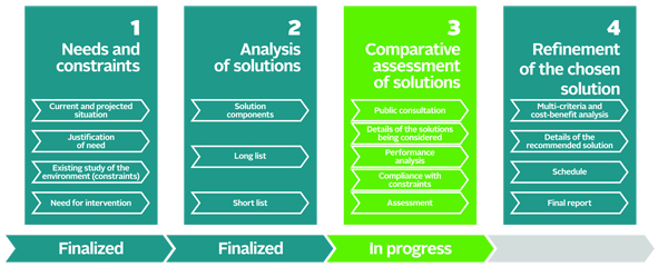
The additional study consists of 4 phases:
- Identify all needs and constraints, for both the current situation and the future;
- Identify the possible solutions and assess them to retain 5 that will be studied in more detail;
- Assess the performance of the 5 solutions chosen and compare them in order to identify the solution that best meets the objectives and constraints identified in phase 1;
- Detail and refine the chosen solution.
To date, phases 1 and 2 have been completed.
The crossing to Ottawa
A structuring public transit system in our region is essential and its success depends partially on efficient travel between Gatineau and Ottawa. To ensure an interprovincial connection, our structuring system must cross over to Ontario. Several options have therefore been examined.
The possibility of inserting trains into Ottawa's light rail tunnel was considered. However, the frequency of the light rail planned for the long term on the Confederation Line unfortunately does not allow for the safe addition of more trains coming from Gatineau.
Consequently, this option does not meet the needs of the current study and has not been retained.
Since it is impossible to use Ottawa's light rail tunnel, it was important to assess the 6 bridges linking Gatineau and Ottawa based on the projection of destinations for Gatineau riders.

Champlain Bridge
The Champlain Bridge offers little potential because of its location too far west. For riders in the Hull sector, it represents a major detour for getting to downtown Ottawa. Furthermore, if the structuring system crossed at this point, it would not go to downtown Gatineau.
However, the Champlain Bridge will continue to be used by bus services to Tunney's Pasture, namely for trips to west Ottawa.
Prince of Wales Bridge
If the Prince of Wales Bridge were chosen to be part of the structuring system, riders going to Ottawa would have to transfer to Ottawa's light rail at Bayview station.
However, the light rail section between Tunney's Pasture and Lyon stations will be the busiest along the Confederation Line. There would not be enough space to accommodate all riders coming from Gatineau.
From this aspect, the Prince of Wales Bridge does not meet the needs of the current study and has not been retained. However, its use is still relevant for a secondary link between Ottawa and Gatineau. In fact, it has been identified in Ottawa's transportation plan in the ultimate network concept.
Chaudières crossing
Bounded by several buildings, including some heritage buildings, Chaudières crossing does not have enough space to insert a structuring public transit axis.
Consequently, the Chaudières crossing does not meet the needs of the current study and has not been retained.
Macdonald Cartier Bridge
The Macdonald Cartier Bridge is too much of a detour between the Aylmer-Taché and Allumettières axes and downtown Ottawa. It could accommodate buses from the regular system, but is not a structuring axis.
The Macdonald Cartier Bridge therefore does not meet the needs of the current study and has not been retained.
Portage Bridge
the Portage Bridge is the best option for the majority of riders. It has a large transportation capacity, especially if it is set up for rail transport. It would take riders close to Lyon station, which would allow STO riders to transfer to the light rail system.
The Portage Bridge appears to be the optimal link to offer an efficient structuring connection between the two sides of the river.
Alexandra Bridge
The Alexandra Bridge is a detour for riders coming from the Aylmer/Taché axis heading to sectors around Lyon and Parliament stations. The Alexandra Bridge does not offer enough benefits to justify the challenges and costs related to inserting a transit alignment to Rideau station.
However, joint use of the Portage and Alexandra bridges could be promising for future developments of the system.
Other solutions
Also considered but were excluded, other solutions such as building a tunnel to cross the river, building a new bridge and a tunnel, and even independent transportation between the downtown areas. These solutions offer riders few benefits since it is possible to use the existing bridges. In addition, the technical challenges and costs are too significant. These solutions have therefore not been retained.
Consequently, further to the assessment, the Portage Bridge has been retained since it appears to be the optimal link to offer an efficient structuring connection between the two sides of the river.
The Alexandra Bridge could be considered for future development of the system and/or for creating a public transit link between the downtown areas of Gatineau and Ottawa.
The Champlain and Prince of Wales bridges would allow for secondary connections between the two sides of the river.
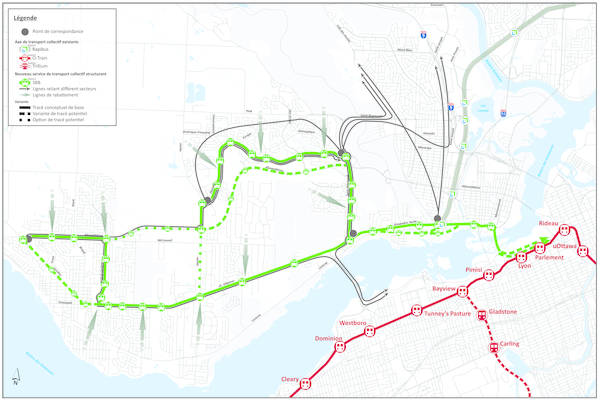
Description of the scenarios
To ensure adequate performance, combining the Allumettières and Aylmer/Taché axes is necessary. The options for the possible scenarios were developed based on these 2 axes.

The anticipated ridership allows 3 transportation mode options to be considered:
- A rail mode, such as a tram along both axes;
- A bus or bus rapid transit mode along both axes;
- A combination of modes: i.e. a rail mode along one axis and a bus mode along the other.
All modes would be electric and designed to meet the principles of universal accessibility.
Get more details on the transportation mode features.
Combining the possible routes in the west, the transportation modes and the options for crossing to Ottawa resulted in a long list of solutions that were analysed according to 9 criteria:
- Population within walking distance
- Nearby employment districts
- Travel time for several origin and destination points
- Quality of service offered for riders, including the number of transfers
- Ease in connecting with the Rapibus corridor and Ottawa's light rail system
- Planning opportunities in transit-oriented development zones
- Number of buses in downtown Ottawa
- Length of segments to build, making it possible to assess the cost of the work
- Potential impacts on the physical and natural environment
Subsequent to this analysis, 5 scenarios are under study. The public consultation process considers these scenarios, among other things.
Reference scenario
The first one is the reference scenario, which includes preferential measures such as reserved lanes or traffic light priority at several locations in the current system, but no structuring measures. It serves as the basis for comparison with the other scenarios.

All-bus scenario
The all-bus scenario includes structuring layouts for buses along the Allumettières/Wilfrid-Lavigne/Aylmer/Taché axes with a branch via Vanier, Plateau and Saint-Raymond.
A variation is possible via Eardley, Allumettières rather than Plateau and in the back of UQO. Connexions between the two axes are possible by Allumettières or Vanier.
To avoid saturating the reserved lanes along Aylmer close to downtown Gatineau and on the Portage Bridge, the service would use articulated or bi-articulated buses.
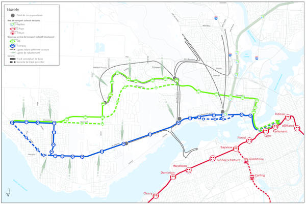
All-rail scenario
The all-rail scenario operates with trams along the Allumettières/Wilfrid-Lavigne/Aylmer/Taché axes with a branch from Plateau to Saint-Raymond.
Variations are possible via Eardley and at the back of the UQO. Variation connections between the two axes are possible either via Allumettières or Vanier.

The next two are hybrid scenarios, with one structuring axis operating in rail mode and the other operating in bus mode.
First hybrid scenario
In the first hybrid scenario, the Allumettières/Plateau axis is served by trams. A variation is possible via McConnell and Allumettières.
The Allumettières/Wilfrid-Lavigne/Aylmer/Taché axis is served by a bus rapid transit system using articulated buses.Variations are possible via Eardley and at the back of UQO.

Second hybrid scenario
In the second hybrid scenario, the Allumettières/Wilfrid-Lavigne/Aylmer/Taché axis is served by trams. Variations are possible via Eardley and at the back of UQO.
The Allumettières/Plateau axis is served by a bus rapid transit system using articulated or bi-articulated buses. A variation served by bus is possible via McConnell and Allumettières.
On the structuring axes, regardless of whether they operate with buses or trams, vehicles will run at a high frequency, or every 5 minutes in peak periods and every 10 minutes in off-peak periods.
A local bus service will be offered in different neighbourhoods to take riders to the stations located along the structuring axes.
If the system uses buses, the local routes could go directly to the downtown areas by taking the structuring axis. If not, then riders would be taken to a local station where they would transfer either to a route heading to downtown Gatineau or to a route heading to downtown Ottawa, as is currently the case along the Rapibus corridor with routes 100 and 200.
For destinations that are not served directly by the structuring system:
- The system will offer easy connections with the Rapibus corridor and Ottawa's light rail;
- To go to the Hull sector, such as the Cégeps on Cité-des-Jeunes or the business and industrial districts along Saint-Joseph and Carrière, bus routes will leave from the Plateau neighbourhood and the Taché / Saint-Joseph intersection.
Evaluation criteria
Subsequent to the consultations, the solutions will be assessed according to the following 5 major topics:
- Serve the greatest number of residences and activity centres
- Improve public transit system performance
- Improve the quality of life of citizens
- Preserve a natural, healthy environment
- Establish the most favourable investment for taxpayers in terms of the service offered
In the end, these analyses will make it possible to identify the solution that best meets the needs of Gatineau residents for the next 30 years.
Implications for the STO's system
The large number of buses that travel through downtown Ottawa means that there are several buses right behind each other. As soon as one bus stops to let passengers on or off, the buses behind it must also stop, which delays all buses.
Moreover, it is not in our clientele's interest to add more buses in downtown Ottawa. This would degrade the quality of service.
With this in mind, several options must be analysed to assess the most effective way to bring riders from Gatineau's various sectors to downtown Ottawa.
In the bus-only scenarios, the routes that currently go to downtown Ottawa will continue to do so, just as they will when Ottawa's light rail starts.
If there is a rail mode, changes to routes will be necessary, but will not be excessive.
Two options are then possible:
In option one, buses coming from the east will continue their route to downtown Ottawa.
The tram and buses would both travel over the Portage Bridge. Upon arriving in Ottawa, different platforms would be built for the trams and the buses.
This option nevertheless still represents many vehicles in downtown Ottawa, so it is necessary to ensure its viability in the long term.
In option two, only the tram from the west will go to downtown Ottawa.
The routes from the Hull sector and east Gatineau will take riders to downtown Gatineau where they can transfer to the tram heading to Ottawa.
To make this connection easier, the tram will have comfortable stations and run at a high frequency.
To avoid a second transfer for riders, it is possible that some local lines will be inserted directly into the Rapibus corridor, which would reduce the number of buses in downtown Ottawa.
These two options are among the scenarios being studied. Variations are also conceivable, for instance it may be possible that some routes go directly to Ottawa.
Building a structuring system
Building a structuring link such as a tram or bus rapid transit system in the current street layout represents an opportunity to redesign street crossings, but it is also a challenge when space is limited.
From the outset, it should be noted that a tram and a bus rapid transit system both require the same amount of space.
In general, the space available on the streets is sufficient between stations. However, at the stations, which are generally located close to intersections, more space is needed in order to build the platforms and turning lanes for the vehicles.
Each street has its own particularities. The types of layouts will be adapted to the locations based on need. For example, on Allumettières the two lanes in each direction and the bike lane will remain. A bike lane will be added along the Aylmer/Taché axis.
The desirable layout for a tram could have the following profile:
- One traffic lane in each direction
- With a turning lane
- Comfortable sidewalks
- Vegetation between stations
- A bike lane
At the stations, the vegetation is replaced by bus shelters and platforms.
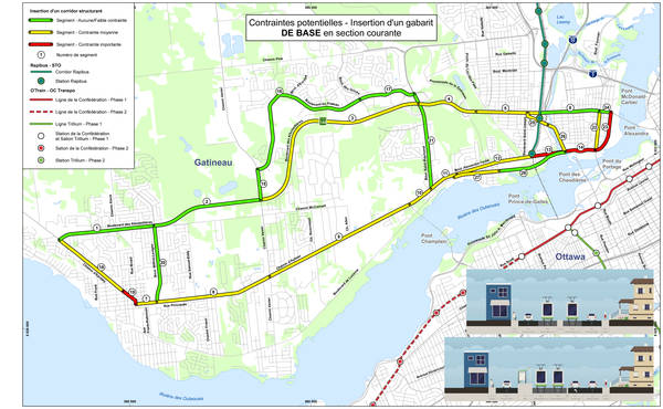
Along Saint-Raymond and the segments farther west along Allumettières, desirable layouts would be possible. (in green on the map)
Along Plateau, a few medium constraints would require some compromises. (in yellow on the map)
Along Aylmer, Alexandre-Taché and Wilfrid-Lavigne, there is generally not enough space to include such layouts. (in red on the map)

To reduce the impacts on the existing environment, the width of lanes, sidewalks and the bike lane could also be reduced to a minimum and vegetation could be left out. The system could then operate just as efficiently, but it would reduce the comfort of riders and the quality of the layout.
Such a simplified layout can be implemented easily on Plateau or on Wilfrid-Lavigne. (in green on the map)
The constraints along Aylmer and Alexandre-Taché would also be less significant than those in the desirable layout. (in yellow on the map)
However, compromises may be necessary in some locations. It may be necessary to remove one traffic lane, relocate a bike lane, eliminate street parking or even expropriate some land on properties.
These decisions will be all the more important if we want to have a comfortable layout with wide sidewalks and vegetation. It is also possible to imagine a more comfortable layout at locations where the impacts would not be as great and, in contrast, a more minimalist layout at other locations.
The consultation currently under way also aims to gather the opinions of Gatineau and Ottawa residents, whether or not they are public transit riders, on the objectives of the transit system, the preferences regarding the service offered and the scenarios being studied.
In order to do this, you are invited to complete an online questionnaire by June 24th to give us your preferences and comments on the proposed scenarios, the different possibilities and the compromises that you feel would be acceptable regarding the layout.
Next fall, once the scenario has been selected, residents that could be affected by these measures will be consulted.
For any questions, contact us at: etudedelouest@sto.ca