
Find out more...
The Wellington With Traffic Scenario
The following provides a brief description of the main elements of this potential scenario to integrate a tram along Wellington Street:
- The tram would operate on the north side of the street;
- Vehicular traffic would be maintained along the entire length Wellington Street, but reduced to one lane in each direction east of Lyon Street;
- Two eastbound right turn lanes from Wellington Street to Lyon Street would be maintained;
- Westbound left turns from Wellington Street to Lyon Street would be permitted, but the left turn lane would be eliminated;
- All other left turn lanes would be eliminated, and at some intersections, the left turns would not be permitted;
- Vehicular accesses to the Parliament complex (there are currently 8 access points) will be affected and all may not be maintained;
- There will be traffic impact on other downtown streets;
- Pedestrian sidewalks would be maintained on both sides of the street, including partial widenings where possible;
- A pedestrian passage under Wellington at Lyon is considered due to the expected high volume of pedestrian crossings at this location;
- A planned two-way cycling facility would be included;
- Some mature trees may be have to be removed; and
- An additional property would be required west of Bank Street.
Options to accommodate the planned cycling facility
Due to a limited available width on Wellington Street, particularly at the proposed Parliament tram station, four options for the integration of the cycling facility were considered:
Option A: Discontinued east of Bank Street
The two-way cycling facility would be provided on the north side of the street between the Portage Bridge and Bank Street but wouldn't be available for the portion of Wellington Street east of Bank Street.
Option B: Shared with pedestrians at Parliament station
The two-way cycling facillity would be provided on the north side of the street, but for a short section in the vicinity of the proposed Parliament tram station (approximately 50 m long), pedestrians and cyclists would have to share the same space.

Option C: Re-routed in front of the Parliament
There would be a continuous two-way cycling facility along Wellington Street, but in the vicinity of the Parliament it would be re-routed from Wellington's roadway edge and proceed along the Parliament internal roadway network.
Note: the plan of option C is displayed east of Bank Street only because it is identical to option A west of Bank Street.

Option D: Continuous, but with reduced widths at the Parliament tram station
There would be a continuous two-way cycling facility along Wellington Street, but in the vicinity of the Parliament tram station, the widths of both the cycling facility (2.5 m) and the adjacent sidewalk (3) would be reduced on approximately 50 meters.
Note: the plan of option D is displayed east of Bank Street only because it is identical to option B west of Bank Street.

The following points relate to the four options:
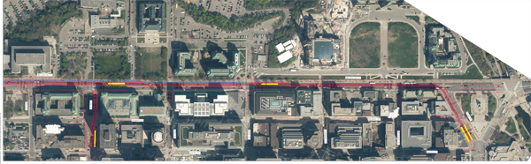
Legend: the tram line is in red, the tram stations in yellow, and the cycle path in blue.
As described above, none of these options are ideal. This corridor has several uses competing for space which would require compromises to be made.
These plans are presented for information only, the various aspects related to integration (impacts on the existing surroundings, intersections affected by the corridor, functional and security contraints, etc.) will be refined during upcoming steps.